Steve Rowell
Dissipation & Disintegration:
Antennas and Debris Basins in the San Gabriel Mountains
2006
In collaboration with the Center for Land Use Interpretation.
An exhibit about the tops and bottoms of the San Gabriel Mountains was presented at the CLUI in the summer of 2006. The exhibit, titled Dissipation and Disintegration: Antennas and Debris Basins in the San Gabriel Mountains was a docu-narrative, shot and presented in high definition video.
Text from the 2006 CLUI exhibition:
The San Gabriel Mountains are the northern limit of Los Angeles, the rim of the urban bowl. Though immobile, they are in flux; moving upwards, due to the mountainbuilding tectonics of the San Andreas fault, and falling down, due to the erosional effects of winter rains, summer fires, and gravity.
When measured from the base to the top—to the peak of 10,064 foot Mount San Antonio (also known as Mount Baldy)—the San Gabriels are taller than the Rocky Mountains. This vertical shift next to the second largest city in the United States presents both a dilemma and an opportunity.
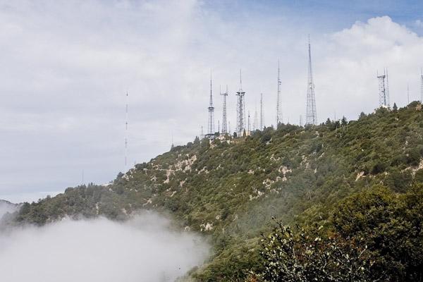
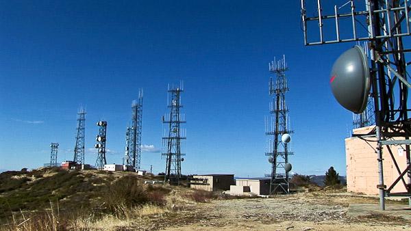
At the base of the mountains lies an extensive system of flood control structures designed to hold back the cascading debris that tumbles down the disintegrating mountains. On the peaks, antennas radiate the transmissions of the city—its television, radio, taxis, fire, police, and telephones—telecommunications that hold the social fabric of the city together. The mountains are an ally and a menace.
The debris basins and antenna sites show the divergent links between humans and the wild: At the top, the mountains are surmounted and used as an electromagnetic platform of social communication and control, radiating forever outward. At their base they must be contained, their inevitable collapse restrained, as they threaten our engineered landscape, and the fragile order we have established.
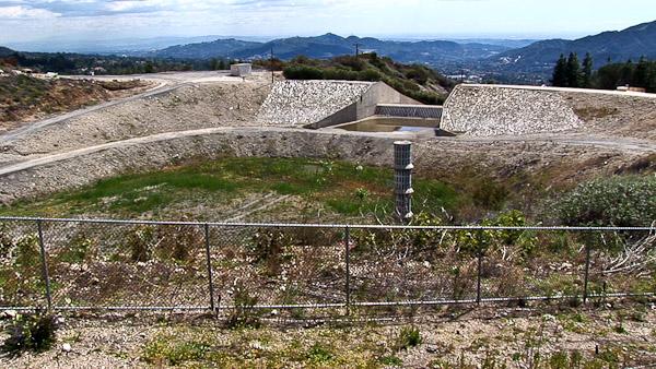
Debris basins can be found at the base of many of the vertiginous washes and canyons in the San Gabriels. The function of the debris basin is to separate debris, including rocks, mud and vegetation, from the storm water that flows down the mountains during the winter rainy season and thereby prevent damage to property and downstream flood control structures.
A debris basin usually consists of an earthen dam, an excavated pit, and a spillway to channel water past the dam. Pipe spillways have vertical pipes with perforations to allow water to be separated from debris. Debris basins require constant maintenance—once they reach about 25% full the debris needs to be removed, trucked off, and disposed of. Due to encroaching development, disposal sites for the debris are getting further away, adding to their expense. Thousands of feet separate these debris basins from the antenna sites above.
The antenna sites depicted in the exhibit form a line along the southernmost ridges and peaks of the San Gabriels. From this elevation, more than a mile above the Los Angeles basin, and with this proximity to the city, these sites allow for line-of-site communications, and for the exposure of the maximum urban area to the electromagnetic emissions of industry, entertainment, and government.
The Forest Service, which owns and manages most of the San Gabriels, has set aside twenty-seven areas in the Angeles Forest for “Designated Communications Sites.” The most congested of these sites, at Mount Wilson, is one of the densest “RF jungles” in North America.
The exhibit at CLUI Los Angeles, supported by the Cultural Affairs Department of the City of Los Angeles, depicted 11 debris basins and 22 antenna sites, from west to east. Each was shot on location by CLUI personnel Erik Knutzen and Steve Rowell. Recordings were also made of the various radio emissions from the antenna facilities, which ranged from commercial radio broadcasts to unintelligable but strangely compelling digital transmission noise. Visitors to the exhibit watched it on a high-resolution video monitor mounted in a kiosk, and listened to it on headphones.
More:
CLUI LOTL newsletter article